Earthquakes and volcanic eruptions are some of the most powerful events on our planet. They remind us that we aren’t standing on “solid ground.” Instead, there are massive machinations and billions of years of planetary evolution at work beneath our feet. They also offer scientists a rare window into the internal workings of our planet.
At the Earth and Planets laboratory, we harness cutting-edge technology to study the internal structure and dynamics of the Earth and the physical processes that give rise to earthquakes and volcanic eruptions. By collecting geophysical data in the field throughout the world, we study a broad variety of problems on many spatial and temporal scales. Studies range from mantle convection and subduction-zone dynamics to the formation and evolution of Earth’s magnetic field.
Ultimately this work allows us to piece together what forces are at work within our planet; helps us foresee and mitigate risks from natural disasters; and may even provide clues as to what Earth and other planets require to sustain life.
In this article, EPL’s geophysicists and geodynamicists highlight five questions that we’re working on to better understand the story of our planet.
What drives the geodynamo?
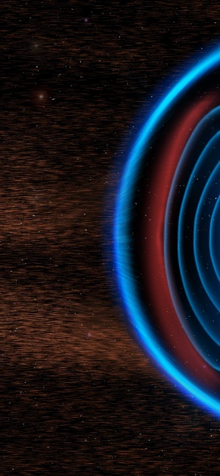
Caption: Earth's magnetic field, generated by the motion of liquid iron deep inside the core, reaches out into space until it is balanced by non-stop flows of Solar charged particles, also known as solar wind. This magnetism conveniently funnels most of the incoming charged particles into polar regions and sometimes generates visible aurorae. Courtesy Carnegie Institution for Science/Roberto Molar Candanosa
The geodynamo is the process by which Earth generates its magnetic field by convection in the liquid iron-rich outer core. Evidence supporting the existence of the ancient geodynamo extends back to at least 3.5 billion years ago—possibly as far back as 4.2 billion years, nearly the age of the Earth itself.
How has Earth maintained a dynamo-generated magnetic field for so long? No one knows for sure, but the answer is intertwined with how Earth has maintained a habitable surface for so long.
The geodynamo that creates the magnetic field is a critical component of Earth's prolonged habitability. It shields the surface of our planet from high-energy particles that are harmful to life. It might even be important for protecting the atmosphere from erosion by solar wind. Understanding what drives the geodynamo and how it may have evolved over Earth history is central to understanding the evolution of life, the atmosphere, and what makes planets habitable in general.
Earth is the only planet known to have maintained an internally generated magnetic field in its core over most, if not all, of its history. The presence of a core-generated planetary magnetic field is commonplace in the Solar System, with nearly every planet either maintaining a present-day core dynamo (Earth, Mercury, Jupiter, Saturn, Uranus, Neptune) or showing evidence of one in the past (Mars). Although there is presently no evidence for a dynamo in Venus, it could have maintained one in the past. Even satellites are capable of dynamo action: lunar rocks show evidence of a now-extinct dynamo in the Moon, and Ganymede, the largest satellite of Jupiter, maintains a dynamo today.
There are three general requirements to maintaining a planetary magnetic field:
1. The presence of a liquid that is electrically conductive—like Earth’s iron-rich liquid outer core
2. Planetary rotation
3. Fluid motion—often generated by the convection of the fluid
Factors (1) and (2) are common but the presence of convection is less of a guarantee.
To drive convection in the core there must be a continuous source of buoyancy to keep the fluid moving. In the modern-day core, this is thought to be predominantly supplied by the release of light elements at the base of the outer core, where the iron-rich liquid solidifies onto the solid inner core. During the solidification, light elements—such as oxygen, silicon, or sulfur—are rejected from the solid and accumulate in the liquid, where they rise and drive convective currents. However, Earth’s inner core (and its solidification process) is likely only about one billion years old based on the cooling rate of the planet’s interior, which is significantly younger than the geodynamo.
Then what was driving convection in the core prior to the solidification of the inner core?
This is one of the hottest topics in geophysics today.
One possibility is that prior to inner core solidification the liquid core was cooling fast enough to drive thermal convection, where the heat being removed exceeded the amount that can be transported conductively—that is without fluid motion. The issue with thermal convection is that iron is a very good conductor of heat, so the core would have had to be cooling rapidly to drive thermal convection. Moreover, the cooling rate would have had to be high for billions of years while not so fast as to freeze the entire core!
Another possibility is that one or more of the light elements in the core could be precipitating out of the core as it cools. In this scenario, a light element phase (such as SiO2) that was once stable in the iron alloy when the core was hotter becomes unstable as the core cools, and separates from the iron alloy at the top of the core. Below where the two liquids separate an iron-rich liquid residue will form and drip down into the liquid core, driving convective currents.
How are we studying the geodynamo?
Staff Scientist Peter Driscoll is currently working on modeling the thermal evolution of the Earth to better constrain the timing of inner core solidification and the cooling rate of the interior, which is critical to understanding what was driving the geodynamo in the deep past. He is also working with Computational Scientist Cian Wilson on first principles 3D dynamo models that generate magnetic fields from rotating convection in a spherical shell. In particular, they are testing how the thermal and chemical buoyancy fields interact and are coupled to each other as the core cools. Ultimately their goal is to better quantify what kinds of magnetic fields are generated from different driving forces and apply that knowledge to better understand the Earth’s thermal evolution from the paleomagnetic record.
How important is plate tectonics for the long-term chemical and physical evolution of the Earth?
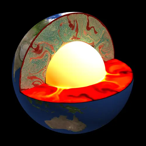
The start of plate tectonics is not well documented in the geological record but has likely been going on for at least the last 3.5 billion of the 4.5 billion years since Earth’s formation.
So how does plate tectonics work? Earth’s internal heat causes convective motions in the rocky mantle that surrounds the iron core. The slow release of heat causes the familiar features of plate tectonics at the surface, with large plates colliding at subduction zones, spreading apart at mid-oceanic ridges, and sliding side by side at transform faults. Volcanism associated with subduction forms dramatic arc volcanoes and their long-time activity has strongly contributed to shaping the continental crust, which is on average 40 km thick and has a dramatically different chemical composition than the Earth’s mantle from which it is derived.
For a long time, scientists assumed that this difference between the crust and the deep mantle—seen in the detailed trace element chemistry of mid-oceanic ridge and ocean island basalts—was primarily caused by processes in the very early Earth combined with the extraction of the continental crust. However, scientists at Carnegie’s Earth and Planets Laboratory thought there was more at play—the formation and recycling of oceanic crust.
A new hypothesis for deep mantle chemistry
While at the Department of Terrestrial Magnetism (now part of the Earth and Planets Laboratory), scientists Al Hofmann and Bill White (Hofmann & White, 1982) suggested a dramatic departure of this thinking, focusing not on the continental crust but rather on the importance of long-term oceanic crust formation and recycling.
They suggested that even though the chemical differentiation that occurs at mid-oceanic ridges is weaker than that occurring at volcanic arcs—forming an oceanic crust of just 7 km thickness compared to the 40 km of continental crust—there is a significant volume of oceanic crust that has formed over the course of Earth’s history due to plate tectonics. The oldest oceanic lithosphere is about 200 million years old while most of the older oceanic crust has been created and recycled back into the planet.
Erik Hauri and Peter van Keken together with Chris Ballentine (University of Oxford) spearheaded research to test the Hofmann & White hypothesis. They confirmed earlier work (Christensen and Hofmann, 1994) that oceanic crust recycling explains the average age of the deep Earth as seen through the decay of uranium to lead (Brandenburg et al., 2008). In addition, the oceanic crust recycling hypothesis shows that the characteristics of other radiogenic isotope systems can be explained by long-term oceanic crust recycling.
In other words, multiple independent tests gave all positive results. Continental crust formation is still an important part of the chemical difference between crust and mantle chemistry, but these studies showed that it may play more of a secondary role when compared to the impact of oceanic crust cycling.
How we’re exploring the role of oceanic crust today
Since van Keken joined the Carnegie Institution for Science from the University of Michigan, oceanic crust recycling has remained a significant focal point of his research to which Carnegie Science Postdoctoral Fellows (Tim Jones, Jonathan Tucker, and Nate Sime) and University of Oxford Postdoc Rosie Jones have taken leading roles. This work further supports the idea that subducting oceanic crust has a major impact on the chemical composition of the deep mantle and the evolution of our planet.
Here are a few examples of this recent work:
- The recycling of oceanic crust plays a major role in the chemical composition of the Earth’s mantle. In Erik Hauri’s last work with Peter van Keken (posthumously published in R. Jones et al., 2019) they demonstrated—using radiogenic systems related to the trace elements hafnium and neodymium—that the recycling of continental crust, long thought to control the behavior of these elements in the Earth’s mantle, was actually secondary to that of the oceanic crust.
- New geochemical modeling (Tucker et al., 2020) has allowed us to come up with better designs for improved geodynamical modeling. van Keken’s team found that while the various isotope systems in the Brandenburg et al. (2008) models satisfactorily covered the observed ones, the distribution in the mantle was upside-down. Depleted components reside in the lower, rather than the upper mantle.
- Oceanic crust may be major contributors to the mysterious large slow shear wave provinces (LSSVPs) seen through seismic tomography. The team hypothesized that the accumulation of oceanic crust over time provides the dominant contribution to the LLSVPs that are seen at the base of the lower mantle (e.g., McNamara, 2019). Tomographic filtering of the structures predicted by Brandenburg et al. (2008) showed that these accumulations would correspond quite well to the LLSVPs observed in tomographic models, which use seismic waves to image the Earth’s interior, much like a CAT scan provides internal images for medical purposes (T. Jones et al., 2020).
- Accumulated oceanic crust affects how fast earthquakes travel through the Earth. Separate work with University of Michigan collaborators Jeroen Ritsema and Sam Haugland (Haugland et al., 2018) showed that these same predicted structures could cause early arrivals of earthquake phases that travel through the inner and outer core. Their quantitative models more or less matched real-world observation.
- The accumulated crust in LLSVPs preserves some primitive mantle. Finally, and perhaps somewhat counter-intuitively, they showed in T. Jones et al. (2021) that the early burial of oceanic crust can lead to the actual preservation of primitive mantle inside the LLSVPs, providing thereby an elegant explanation of the combined presence of primitive mantle amidst recycled oceanic crust and depleted mantle.
The future is FEniCS!
As a final note, the work above has benefited greatly from recent development in computational infrastructure for geodynamical modeling led by Postdoc Nate Sime and Computational Scientist Cian Wilson. Their novel FEniCS (fenicsproject.org) approach casts differential equations that arise from the physical description into a symbolic form that is then translated to high-quality finite element code by an automated process (e.g., Wilson et al., 2017; Geballe et al., 2020; Sime et al., 2021). This greatly enhances the quality of the dynamical models and allows for rigorous testing of their quality.
This work builds on the Carnegie Institution tradition to be at the forefront of technique and instrument development—allowing Earth scientists to “see better” (paraphrasing the Carnegie Institution’s Centennial history “Good Seeing”, Trefil and Hazen, 2002).
How do volcanoes work?
By Hélène Le Mével and Diana Roman
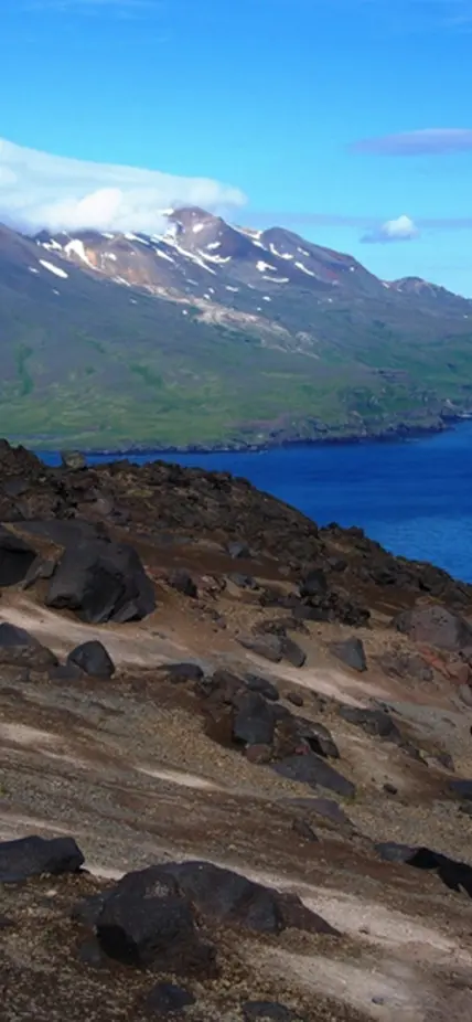
Caption: EPL Staff Scientist Diana Roman collecting samples from Cleveland Volcano, with Tana Volcano on Chuginadak Island in the background in the Aleutian Island chain. Recent work shows that the Cleveland Volcano along with the Tana, Herbert, Carlisle Volcanoes could actually be part of a single, previously unrecognized giant volcano, or interconnected caldera, in the same category as Yellowstone, according to work from a research team, including Carnegie’s Diana Roman, Lara Wagner, and Hélène Le Mével, as well as recently departed postdocs Daniel Portner and Helen Janiszewski.
One of the biggest challenges in volcanology is to identify and understand eruption precursors (NASEM, 2017).
Staff Scientists Hélène Le Mével and Diana Roman use geophysical observations to study magmatic processes beneath volcanoes. By improving our understanding of volcano deformation we will be better able to interpret future patterns of deformation, including pre-eruptive deformation. Studies of volcanic seismicity and deformation are complementary and together with other observables such as volcanic gas flux and composition help forecasting eruptive behavior.
What can volcanoes tell us before they erupt?
Diana Roman’s research straddles the boundary between volcanology and seismology and focuses on understanding source processes of volcanic earthquakes, volcano-fault interaction, the structure and dynamics of magma transport and storage systems, and the nature of geophysical precursors to eruptions.
Roman's primary research efforts are aimed at identifying, documenting, and understanding systematic patterns in precursory volcanotectonic (VT) earthquake swarms and crustal stress field orientations during episodes of magma ascent. In particular, she explores the potential of volcanic stress field analysis as an eruption forecasting technique. To do this, she analyzes volcano-seismic data from around the world, sometimes waiting for years for the right scenario to present itself so she can study a hypothesis.
For example, in a recent study of the 2018 Kilauea eruption, Roman was able to connect earthquakes’ fault orientation before a volcanic eruption to the viscosity of magma beneath the volcano. Before this study, there was no way to guess what the viscosity of magma would look like, but the type of magma is one of the most important features of a volcanic eruption when it comes to risk mitigation. Thicker magma may be more explosive but travel slower. Thinner magma on the other hand might not lead to a dramatic eruption, but it tends to move quickly and can overtake roads, homes, and communities.
This study, which was 20 years in the making, may provide emergency managers on the ground with a new forecasting tool and an invaluable head start when it comes to planning for an eruption.
Studying changes in the Earth’s surface
Staff Scientist Hélène Le Mével uses geodetic data and numerical models to study active volcanoes. Magmatic processes taking place in the reservoir and conduit generate small deformation of the ground surface. For example, during magma intrusion, the magma reservoir can be pressurized due to a new magmatic intrusion, which will deform the crust around it and lead to the uplift of the ground surface.
Le Mével is particularly interested in analyzing uplift patterns measured at volcanoes using radar interferometry and GPS methods, which allow detecting sub-centimeter ground motion. Her group is also developing new physical models to allow linking observations of surface deformation to the magmatic processes taking place underground. This research includes work led by postdocs Tara Shreve and Yan Zhan.
For example, Le Mével recently published a study of magma injection at an uplifting volcano in the active Laguna del Maule volcanic field in Chile: https://link.springer.com/article/10.1007/s00445-021-01457-0
Using gravity to see into volcanoes
A second and related question is to determine where and how is magma stored in the crust under volcanoes.
To that end, Hélène Le Mével uses gravity measurements acquired both in the field and from satellites, which are valuable data sets to reveal density contrasts underground. By mapping gravity anomalies we can determine the depth and geometry of the magmatic system (including one or several melt reservoirs and possibly an associated hydrothermal system). Knowing where magma is stored is an important question to be able to have realistic models and accurate forecasts. In a recently funded NSF project, Le Mével aims to map the gravity anomalies associated with the Three Sisters Volcanic Complex in the Cascades, which also have been inflating for the past two decades. The first of 3 field gravity campaigns will happen in September 2021. This project aims to determine the long-term evolution of magma storage and how it links to the recent short-term inflation episode.
Gravity data derived from satellite altimetry can also help determine crustal density anomalies associated with submarine volcanic systems. A recent example using such data is found in the ongoing multidisciplinary study of the Islands of the Four Mountains, in Alaska which included Carnegie’s Diana Roman, Lara Wagner, Hélène Le Mével, and former postdoc Daniel Portner. This work provided evidence that indicates that the islands could, in fact, belong to a single interconnected caldera.
Using these altimetry-derived gravity data, H. Le Mével aims to shed light on the magma storage conditions at other submarine volcanoes in the Tonga and Kermadec arcs as well as at a submarine volcano offshore Mayotte (Comoros archipelago, Indian Ocean) that formed during the ongoing eruption started in 2018.
What drives Earth’s deepest quakes?
At the Carnegie Science’s centennial celebration, the scientists put together a list of the 100 top questions in science at the time. One of those questions was, “What are the mechanisms of deep-focus earthquakes.”
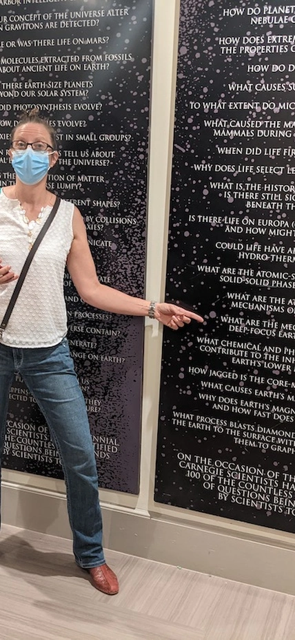
Caption: Lara Wagner points to the question, "What are the mechanisms of deep-focus earthquakes,” as a part of the top 100 questions in science display at the Carnegie Headquarters. Recent collaborative work by EPL scientists has shown that water and other fluids are major components of these mysterious quakes.
Most earthquakes occur close to the Earth’s surface, down to about 70 kilometers. They happen when stress builds up at a fracture between two blocks of rock—known as a fault—causing them to suddenly slide past each other.
However, deeper into the Earth, the intense pressures create too much friction to allow this kind of sliding to occur and the high temperatures enhance the ability of rocks to deform to accommodate changing stresses. Though theoretically unexpected, scientists have been able to identify earthquakes that originate more than 300 kilometers below the surface since the 1920s.
New research published in AGU Advances provides evidence that fluids play a key role in deep-focus earthquakes—which occur between 300 and 700 kilometers below the planet’s surface. The research team includes Carnegie scientists Steven Shirey, Lara Wagner, Peter van Keken, and Michael Walter, as well as the University of Alberta’s Graham Pearson. This study is unusual in applying four different disciplines—geochemistry, seismology, geodynamics, and petrology—to the same question, all of which point to the same conclusion: water and other fluids are a key component of deep-focus earthquakes.
How do we "translate" seismic velocity images into geological terms?
By Lara Wagner
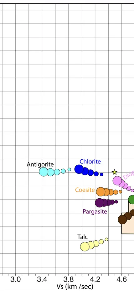
These plots show the ratio of compressional (Vp) to shear (Vs) wave seismic velocities. The left figure shows commonly accepted values from 2004 (Hacker & Abers, 2004). The right figure shows our most recent calculations that were presented at AGU 2019. Particularly remarkable are the changes in the velocities of hydrous phases like antigorite and talc that are expected to play important roles in subduction zones where ample water is available. Courtesy of Lara Wagner/Carnegie Institution for Science
Studying the Earth’s interior is particularly challenging because we cannot see through rock. Or can we?
Carnegie scientists like Lara Wagner and Diana Roman follow on a long legacy set by emeritus Carnegie scientists David James, Selwyn Sacks, Alan Linde, and Paul Silver of collecting seismic data sets in order to image the interior of the Earth. However, when it comes to telling us what types of rocks are under our feet, progress has been limited by technology.
Seismologists place arrays of seismometers at the Earth’s surface to capture these waves after they’ve passed through the Earth and then use mathematical models to map out which waves passed through fast or slow materials, and where those fast/slow materials are located. Scientists can observe as seismic waves “bounce” off sharp boundaries in the Earth, which helps us image edges and shapes with higher fidelity.
This seismic imaging allows us to learn about structures below our feet in much the same way that ultrasound imaging or CAT scans allow us to learn about structures below our skin. Earthquakes produce waves that travel through the entire planet. As they go along, they travel faster or slower depending on the types of rocks they pass through. Seismic waves travel faster through rocks that are cold, for example, than through rocks that are hot. Different types of rocks, and rocks at high pressures, can also affect seismic wave speeds.
One limitation of these images is that they can only show us what areas of the Earth have faster or slower seismic wave speeds.
The ability to map those wave speeds to specific physical properties of rocks (temperature, pressure, composition, melt/fluids) is the next frontier in seismic imaging and depends on continued experimental and theoretical research of mineral properties under pressure. Seismologists at Carnegie collaborate with geochemists, petrologists, and mineral physicists like Steve Shirey, Mike Walter, Yingwei Fei, and Anne Pommier to decrypt these seismic signals into accurate representations of physical properties deep in our planet’s interior.
