New Report Outlines a Major Initiative to Study Geologic Hazards Related to Subduction Zones

Washington, DC—A new report, co-authored by Carnegie’s Diana Roman, presents a plan for an ambitious interdisciplinary initiative aimed at advancing understanding of the processes that trigger earthquakes, tsunamis, landslides, and volcanic eruptions where tectonic plates converge.
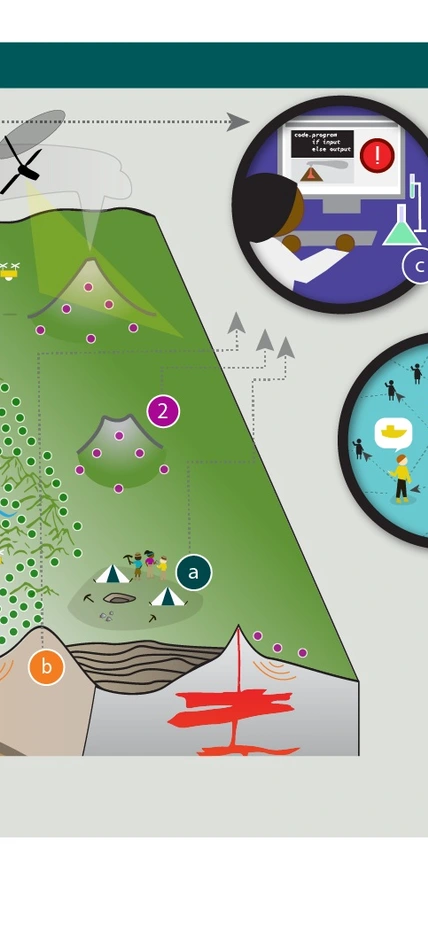
Subduction zones are found around the world, mostly in coastal regions where an oceanic tectonic plate dives beneath a continental plate. The resulting geohazards include Earth’s largest earthquakes and tsunamis, volcanic eruptions, and landslides. Many large population centers are situated along subduction zones and are vulnerable to these hazards.
Years in the making, a report from the Subduction Zones in Four Dimensions (SZ4D) Research Coordination Network presents an ambitious plan to make major advances in understanding subduction zone hazards by bringing together a diverse community of scientists in a long-term collaborative effort, deploying new instrumentation in subduction zones, making detailed geologic observations, and developing more sophisticated and accurate models.
“This effort will increase our understanding of the geologic processes occurring in subduction zones and the hazards that threaten many densely populated areas,” said Roman, a member of SZ4D’s Executive Committee. “It’s an excellent example of the kind of strategic, cross-disciplinary collaboration that is needed to advance our knowledge and help inform the work of urban planners and emergency managers.”
Major advances in understanding the science behind subduction zone hazards will yield tangible benefits for communities in the affected regions, including the possibility of useful forecasts of large earthquakes, volcanic eruptions, and landslides.
“We’re not promising that we will be able to predict anything,” said Emily Brodsky of UC Santa Cruz, who chairs the SZ4D steering committee. “But we need to figure out if our inability to predict these things is related to the fundamental properties of the system, or because we just haven’t had the instruments in the right place at the right time.”
The initiative was born out of a 2016 workshop, which produced a vision document, and the U.S. National Science Foundation funded the development of the detailed plan in this week’s report. Through a series of meetings, workshops, webinars, and town halls designed to engage the U.S. research community and solicit input, the SZ4D initiative identified community priorities and the key infrastructure requirements and science activities needed to better understand geohazards and reduce their risks to society.
“It’s been a huge community effort,” Brodsky added. “This is the right time to put serious resources into the question of whether these events are predictable or not. That’s something we’re poised to address now.”
The implementation plan involves a major effort to improve observations of subduction zones in a systematic way, collecting a diverse set of measurements at a range of scales both on land and under the sea. The infrastructure required for this includes extensive arrays of instruments to monitor different facets of subduction zone behavior, including volcanic unrest, and surface and environmental conditions related to landslides.
The plan also calls for researchers to study the geologic context, conduct laboratory experiments, and build computational models that integrate field observations and laboratory data.
In the United States, the greatest risk is associated with the Cascadia subduction zone off the coast of the Pacific Northwest. However, Cascadia is not the best place to concentrate research efforts because it moves so slowly. The Chilean subduction zone is geologically active enough to provide useful information and is a good locale for comparative studies with Cascadia and Alaska. The SZ4D implementation plan recommends deploying instruments at all three sites, but with the majority of the observational efforts occurring in Chile, complemented by a substantial portfolio of scientific activities in Cascadia and Alaska.
The initiative has already started building partnerships with Chilean scientists, as well as international groups studying the Chilean subduction zone.
The SZ4D initiative is organized into three working groups—Landscapes and Seascapes, Faulting and Earthquake Cycles, and Magmatic Drivers of Eruption—and two integrative groups—Building Equity and Capacity in Geoscience and Modeling Collaboratory for Subduction—with a total of 74 members from 55 universities and institutions. The next SZ4D Community Meeting will be held November 14 to 16 in Houston.
Additional information is available on the SZ4D website at www.sz4d.org.